Flagship Exhibit · APUSH Period 2 · 1607–1754
Why Did British America Become So Different?
Thirteen colonies shared a crown. They did not share one colonial experience.
Companion Assignment · 20 points
Open your workspace before you continue.
This exhibit and the Canvas assignment are designed to work together. Open the assignment in a second tab, then return here. At each checkpoint, you will have enough evidence to complete the next response without turning the exhibit into a scavenger hunt.
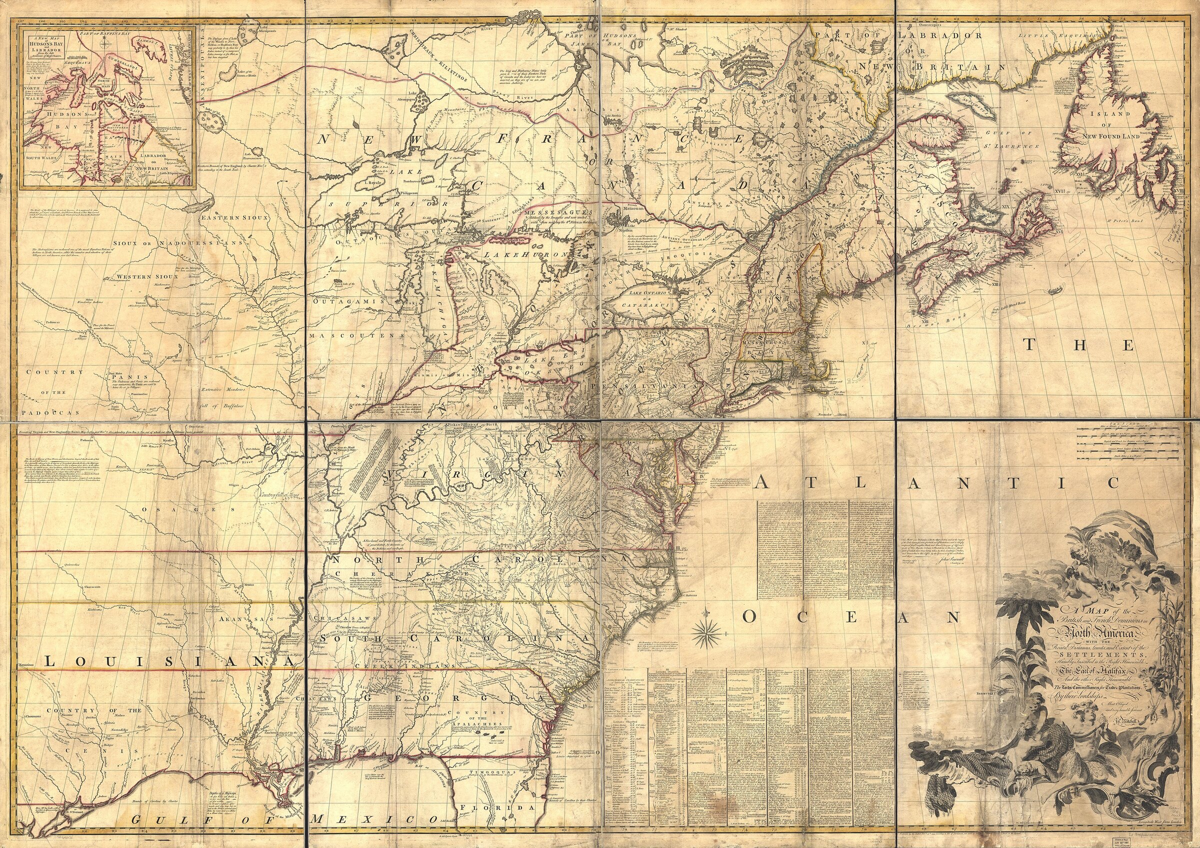
Primary Map · John Mitchell, 1755
Begin with the geography British colonists claimed.
Study the period map first. It shows the colonies within a larger Atlantic and imperial world; the colored markers identify places to explore, while the map itself remains the historical artifact.
Sample the regions, then follow your curiosity.
Opening one colony from each region gives you a useful comparison. It is an invitation, not a required checklist.
- New England Not yet
- Middle Colonies Not yet
- Chesapeake Not yet
- Lower South Not yet
Opening Prediction
Which force will best explain regional difference?
Choose a provisional idea if it helps you read the evidence. This is a quick museum prompt—not the companion assignment.
No choice is automatically correct. The strongest explanation will show interaction among causes.
Colonies were not blank slates.
Conditions opened possibilities. People made choices. Institutions made some outcomes durable. Use these factors to explain why regional societies diverged.
Causation Lab
What makes a region become a region?
Select a factor, then trace how it can reshape several parts of colonial life at once.
Environment shapes possibilities.
Climate, soil, waterways, and disease environments influenced settlement and economic choices, but they did not determine a single outcome.
Primary source: The Virginia Company’s instructions prioritized a defensible, healthy, fertile site near navigable water and trade.
Geography mattered, but geography did not force colonists to choose tobacco, slavery, Puritan settlement, or religious pluralism. Historical outcomes emerged from choices made within particular conditions.
Before Jamestown existed, investors were defining its priorities.
The Virginia Company told settlers how to choose a site. Mark language about defense, health, transportation, and trade.
“When You have made Choise of the River on which you mean to Settle, be not hasty in Landing Your Victual and munitions … make Election of the Strongest most fertile and wholesome place … if you Choose your place so far up as A Bark of fifty tuns will float then you may … better Receive the trade of all the Countries about you in the Land.”
Compare the same factor across every region.
This is the exhibit’s central comparison. The atlas supplied colony-level detail; this workspace makes four regional patterns visible so you can explain difference without treating any region as a stereotype.
Comparison Lens
Hold the question constant. Change the region.
Select one lens to place four regional answers side by side.
New England: covenant and obligation
Winthrop addressed Puritan migrants bound for Massachusetts Bay.
“Now the onely way to avoyde this shipwracke … is to followe the counsell of Micah, to doe justly, to love mercy, to walk humbly with our God. For this end, wee must be knitt together, in this worke, as one man. Wee must … abridge ourselves of our superfluities, for the supply of other’s necessities.”
Middle Colonies: liberty and government
Penn prefaced Pennsylvania’s Frame of Government with a theory of political authority.
“We have … composed the frame and laws of this government, to the great end of all government … to secure the people from the abuse of power; that they may be free by their just obedience … for liberty without obedience is confusion, and obedience without liberty is slavery.”
Who would do the work—and who would hold power?
Labor is one regional mechanism, not the whole explanation. In the Chesapeake, changing answers transformed law, race, family, wealth, and resistance.
Indentured migrants supplied much of the early workforce; Africans were also present from the colony’s early decades.
Planters increasingly pursued permanent, hereditary enslavement as life expectancy and access to labor changed.
Virginia consolidated legal distinctions among enslaved people, indentured servants, and free colonists.
Law Sequence · Virginia
Slavery was constructed statute by statute.
Virginia’s early labor force included English indentured servants and Africans whose legal status was not yet governed by one comprehensive slave code. Individual court cases and statutes gradually narrowed possible routes to freedom and gave masters more permanent control.
Read the laws in order. For each one, identify the uncertainty lawmakers addressed, the boundary they created, and whose power the law strengthened.
Status follows the mother
Virginia lawmakers made a child’s status follow the condition of the mother, establishing a hereditary rule that protected enslavers’ claims across generations.
Historical question: What uncertainty did this act resolve, and how did the rule make slavery hereditary?
African expertise shaped the rice economy.
Enslaved West Africans carried knowledge of wet-rice cultivation, processing, and water control. Planters extracted that expertise while claiming the profits it produced.
Forced migration did not erase culture.
Africans and African Americans built kin networks, spiritual practices, language, foodways, and Gullah Geechee culture under brutal constraints.
Enslaved people contested bondage.
Resistance included work slowdowns, preserving family and culture, escape, and revolt—including the Stono Rebellion in South Carolina in 1739.
Explore the National Park Service study of Lowcountry rice, labor, and African knowledge
Virginia · 1676
What was Bacon’s Rebellion?
Nathaniel Bacon led an armed uprising against Governor William Berkeley during a crisis over frontier security, political power, land, and relations with Native nations. Bacon’s forces attacked Native communities—including peoples allied with Virginia—drove Berkeley from Jamestown, and burned the colonial capital.
Read the full historical overview at Encyclopedia Virginia (opens in a new tab)
Labor demand, the declining migration of English indentured servants, the expanding Atlantic slave trade, land pressure, racial ideology, and elite fears of unrest all contributed. Virginia’s transition toward hereditary racial slavery began before 1676 and accelerated afterward; it was a process, not a switch flipped by one rebellion.
Colonial development was also Native history.
Native relations help explain regional difference because Native nations shaped the possibilities, limits, and consequences of colonial development. “English versus Indians” is never a sufficient explanation.
Select a case to examine Native goals, English goals, and a turning point.
Native Diplomatic Evidence · 1722
“We now renew and brighten the Covenant Chain.”
At Albany, Haudenosaunee speakers used the Covenant Chain metaphor to describe an alliance that required continual maintenance. The surviving text passed through colonial recorders and translation, so read both the diplomatic language and the archive critically.
“We are come now to renew the Covenant Chain that has been of old between the Christians of this Government & us … we now brighten & make clear & clean, so that it can never be broken.”
A map labeled “British colonies” can make colonization look complete. It was not. Colonial borders were imperial claims laid across Native political worlds that remained powerful and contested.
Different regions. One Atlantic system.
Atlantic connections did not erase regional difference; they helped produce it. Goods, people, ideas, credit, disease, and coercion connected British North America to the Caribbean, Africa, Britain, and one another.
Trace a Commodity
Follow production into power.
Choose an export. Trace production → labor → commodity → destination → wealth and power.
Select a commodity to reveal its Atlantic chain.
By 1754, the colonies were becoming more different and more connected at the same time.
Regional specialization deepened difference. Commerce, forced migration, imperial institutions, war, and ideas tightened connections.
Difference was produced.
Return to the central question: which causes mattered most, how did they interact, and how did they produce different regional societies? Use the tools below to organize your thinking; the companion assignment—not this exhibit—will contain the assessed writing.
Choose any selections that help you organize the evidence. Your assessed explanation belongs in the companion assignment.
Revisit Your Prediction
You have not recorded an opening hypothesis yet.
After testing the evidence, would you keep, revise, or replace that hypothesis?
Return to the atlas if you need to record a prediction.
Return to the Central Question
Why did distinct regional societies develop within Britain’s North American colonies?
A strong answer establishes a hierarchy of causes, shows interaction, uses specific evidence, and recognizes that divergence occurred within Native homelands and an increasingly connected Atlantic world.
Optional Exploration Guide
There is no required path.
Use these invitations to decide where to go next. The exhibit records exploration for your convenience; it is not an assignment submission or grade.
- Sample a regionExplore
- Open a causal sourceExplore
- Compare regional patternsExplore
- Explore a labor lawExplore
- Examine Native goalsExplore
- Trace an Atlantic connectionExplore
- Organize evidence if usefulExplore
Ready to submit?
Return to Canvas when your responses are complete.
The exhibit is your evidence space; Canvas is the place to submit the 20-point companion assignment.
Sources and map note
The exhibit is aligned to the College Board AP U.S. History Course and Exam Description. Primary texts link to full transcriptions or digitized editions from Plimoth Patuxet Museums, Yale’s Avalon Project, Encyclopedia Virginia, Hanover Historical Texts, the Elizabeth Murray Project at California State University Long Beach, Teaching American History, Wikimedia Commons and the Internet Archive, and the Oklahoma State University Digital Collections. The atlas uses a web-optimized reproduction of John Mitchell’s 1755 map of the British and French dominions in North America, engraved by Thomas Kitchin. The map is a historical artifact shaped by eighteenth-century knowledge and British imperial priorities; the modern markers and colony index are teaching overlays. Colony profiles synthesize standard historical reference information and intentionally name Native nations rather than treating land as empty.